
Why do we need another shared use path in Park 4?
Currently the only sealed (bitumen) shared use path in Park 4 is the Park Lands Trail, which is a recreational shared use path which indirectly connects Parks 2 and 5.
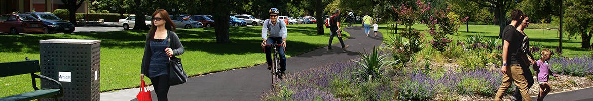
To provide move convenient access to local facilities for local residents, ensure that everyone (regardless of their mobility needs) has access to the Park Lands and to support walking and cycling as an alternative and healthier transport mode to the car then direct and low-stress walking and cycling routes that link to other paths need to be provided.
This proposed path will form part of the:
How many trees are being removed?
No significant or regulated trees are planned to be removed as part of this project. Several trees will be removed; however all of these are small and in poor condition. All tree removal will be offset by new plantings of appropriate species.
The high planting densities and vegetation in Park 4 has resulted in some trees maturing with poor health. Further pruning (in line with Australian Standard) is planned to take place to improve the health of the trees, improve sight lines to the path from Barton Terrace East, and improve the distribution of light from existing street lamps to support public safety.
Will lighting be installed along with the new path?
Who is funding this project?
The project is jointly funded by the Department of Planning, Transport and Infrastructure and Council. The total cost of the project is expected to be $200,000.
What impacts will this project have?
The key project impacts are outlined below.
Shared use path alignment
The use of the existing O’Connell Street footpath as a shared use path requires some localised path widening around bus stop 6 immediately north of Barton Terrace East. Using this existing footpath, which is currently not well used by pedestrians, reduces the amount of paved surface in the Park Lands, as well as minimising project cost.
The alignment of the new shared use path section that runs adjacent to Barton Terrace East follows the existing well-worn gravel path and has been selected to minimise the impact on the Park Lands, including on existing trees and vegetation.
Trees and vegetation removal
No significant or regulated trees are planned to be removed as part of this project. Several trees will be removed; however all of these are small and in poor condition. All tree removal will be offset by new plantings of appropriate species.
The impacts to the tree root zones due to the construction of the path have been minimised through the design process – by lifting up the finished level of the path from its existing level to reduce the excavation required for path construction.
During construction, works will be guided by Council’s qualified arborist and appropriate steps will be taken to ensure that works do not impact on existing vegetation.
The high planting densities and vegetation in Park 4 along Barton Terrace East has resulted in some trees maturing with poor health. Further pruning (in line with Australian Standards) is planned to improve the health of the trees, improve sight lines to the path from Barton Terrace East and improve the distribution of light from the existing street lamps to support public safety.
Why do we need another shared use path in Parks 18, 19 and 20?
The existing track along the proposed path alignment is currently well utilised but is unsealed and in poor condition. The paths are unable to be used in all weather conditions, with puddles remaining on some sections after rain.
The proposed paths will provide move convenient access to local facilities for local residents, local sporting groups and Pulteney Grammar School, and ensure that everyone (regardless of their mobility needs) has access to the Park Lands. The proposed direct and low-stress walking and cycling routes will also support walking and cycling as an alternative and healthier transport mode to the car.
This proposed path will form:
How many trees are being removed?
No significant or regulated trees are planned to be removed as part of this project. Several trees will be removed; however all of these are small and in poor condition. All tree removal will be offset by new plantings of appropriate species.
What is the status of the Frome Street Bikeway review?
The Frome Street Bike-way was installed in early 2014, which included kerb-side separated bike lanes between Carrington Street and Pirie Street, two-way cycling in the one-way Castle Street and Charlotte Street and shared walking and cycling paths in the Parks 18 and 19.
As a result of the Council meeting on 13 May 2014, Council is undertaking an independent review of the bike way to gain feedback from stakeholders, assess if the project was a success, and if any improvements need to be made to improve usability and safety. The review is expected to be completed and presented to Council in mid-2015.
Will lighting be installed along with the new path?
Lighting has not been included along the proposed shared use path. There will, however, be some light spill from the existing street lighting to the path. At night, people will be more likely to use the footpath or road due to the low night time traffic volumes on the adjacent South Terrace. Locations where the shared use path crosses a road have been assessed to ensure lighting meets the Australian Standards.
As a separate project, a lighting master plan is to be developed to identify which Park Lands paths should be lit.
Who is funding this project?
The project is jointly funded by the Department of Planning, Transport and Infrastructure and Council. The total cost of the project is expected to be $200,000.
What impacts will this project have?
The key project impacts are outlined below.
Shared use path alignment
The alignment of the new shared use path section that runs adjacent to South Terrace follows the existing well-worn gravel path and has been selected to minimise the impact on the Park Lands, including on existing trees and vegetation.
The path will be 3 metres wide except at path pinch-points (near trees and the Glover Playground), where the width of the path will be 2.5 metres to reduce costs and impacts on vegetation.
Trees and vegetation removal
No significant or regulated trees are planned to be removed as part of this project. Several trees will be removed; however all of these are small and in poor condition. All tree removal will be offset by new plantings of appropriate species.
The impacts to the tree root zones due to the construction of the path have been minimised through the design process – by lifting up the finished level of the path from its existing level to reduce the excavation required for path construction.
During construction, works will be guided by Council’s qualified arborist and appropriate steps will to ensure that works do not impact on existing vegetation.
Who can I contact for further information?
For more information, please contact
Name: Daniel Keller
Title: Transport Planner
Phone: 8203 7834
Email Address: d.keller@adelaidecitycouncil.com
Are there alternative ways to provide my feedback?
Yes, you can
Complete a hard-copy pack located at our centres
Drop into one of our 6 centres (libraries, communities, and customer centre)
located around the City and North Adelaide and ask one of our friendly
staff for a hard-copy consultation pack which contains project
information and a submission form.