Share Consultation Outcome on Facebook
Share Consultation Outcome on Linkedin
Email Consultation Outcome link
Public consultation on Kangatilla (Park 4) and Wita Wirra (Park 18), Pityarilla (Park 19) and Kurangga (Park 20) shared use walking and cycling projects was undertaken from 27 February to 22 March 2015. All submissions have been reviewed and are summarised in the Consultation Summary Reports.
The Consultation Summary Reports can be downloaded using the below links:
In summary:
- 24 people responded to the Kangatilla (Park 4) shared use path consultation, with 20 respondents (83%) supporting the project.
- 25 people responded to the Wita Wirra (Park 18), Pityarilla (Park 19) and Kurangga (Park 20) shared use path consultation, with 23 respondents (92%) supporting the project, including support from South West City Residents Association, City South Association, Hutt Street Precinct Association and Adelaide Harriers Athletics Club Inc.
- Both consultations also sought feedback on the proposed tree and vegetation removal/pruning. The general feedback was that where tree removal and pruning is justified it is supported by the community.
The feedback received assisted in determining that no further design changes to the Shared Use Path designs were required.
A Report was presented to Council on the 12 May 2015 seeking endorsement to construct the shared use paths. Council endorsed the construction of the projects, subject to the removal of the pedestrian connection and kerb ramps linking from Kangatilla (Park 4) shared use path to Margaret Street north. This was due to Council Member concerns that the inclusion of the pedestrian connection would result in an increase in activity along Margaret Street and that the additional infrastructure was not necessary. The Council Report, including Meeting Minutes can be viewed on Council's Website.
Construction is expected to commence in June on Park 18, 19 and 20, and in mid-late 2015 for Park 4, all affected stakeholders will be informed prior to construction works commencing.
Share Project Information on Facebook
Share Project Information on Linkedin
Email Project Information link
Council sought your thoughts, ideas and comments on a proposed shared use walking and cycling paths in the Park Lands. The paths will create an accessible route for people who walk or ride bikes through North Adelaide and South Park Lands areas, and increase opportunities for residents to enjoy active recreation pursuits in a natural setting.
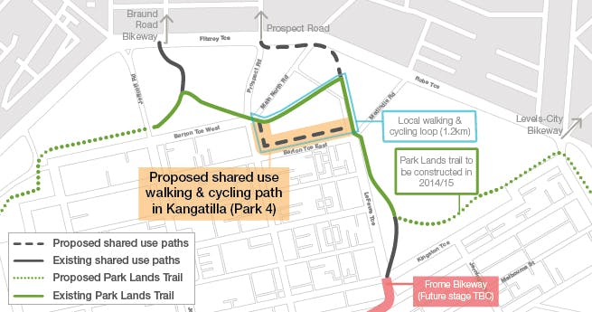
Kangatilla (Park 4)
The path for Park 4 will form the final part of a local neighbourhood walking and cycling loop through Parks 4 and 5, connecting directly to the North East Park Lands Activity Hub. The path will also connect with existing and planned safe cycling bike-ways routes, including the Braund Road Bike-way to Prospect, the Park Lands Trail and the north-south Frome Bike-way.
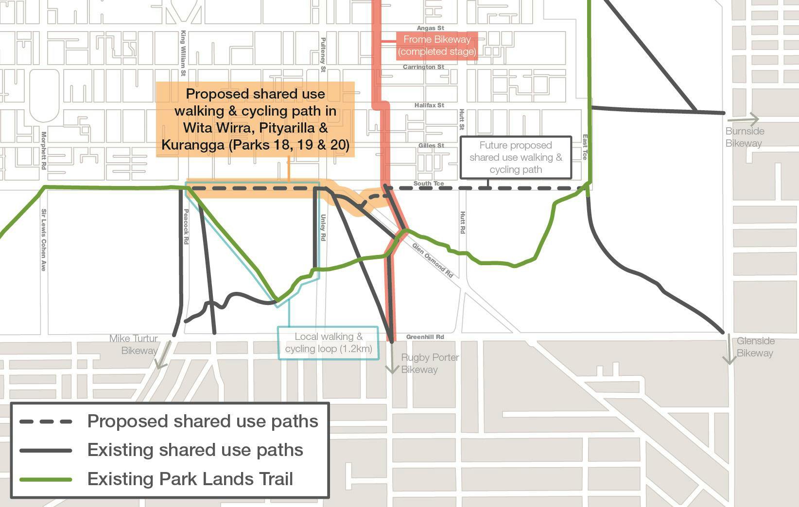
Wita Wirra (Park 18), Pityarilla (Park 19) and Kurangga (Park 20)
The path for Parks 18, 19 and 20 will form the final part of a 1.5km long local neighbourhood walking and cycling loop through the South Park Lands. The path will also connect with existing and planned safe cycling bike-ways, including the Mike Turtur Bike-way and the north-south Frome Bike-way.
To find out more:
Browse the
FAQs for commonly asked questions about this project.
View the
Context Maps on the right-hand side for the overall concept.